VVestiges of New York49,000+ historical photos
MapBrowseAboutGet the iPhone app (opens the App Store)
  1. Browse /
  2. Manhattan /
  3. This place

Houston Street & Orchard Street, Manhattan

4 historical photos taken here between 1934 and 1937, oldest first.

See this spot on the map

Photos

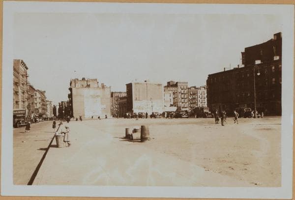
  • Manhattan: Houston Street (East) - Orchard Street, 1934

    Manhattan: Houston Street (East) - Orchard Street

    1934

  • Manhattan: Houston Street (East) - Orchard Street, 1934

    Manhattan: Houston Street (East) - Orchard Street

    1934

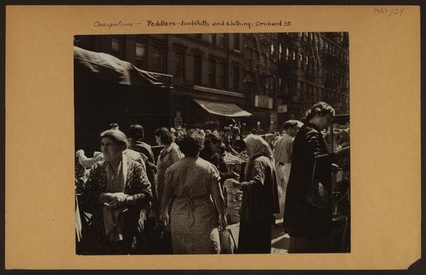
  • Occupations - Peddlers - Foodstuffs and Clothing., 1937

    Occupations - Peddlers - Foodstuffs and Clothing.

    1937

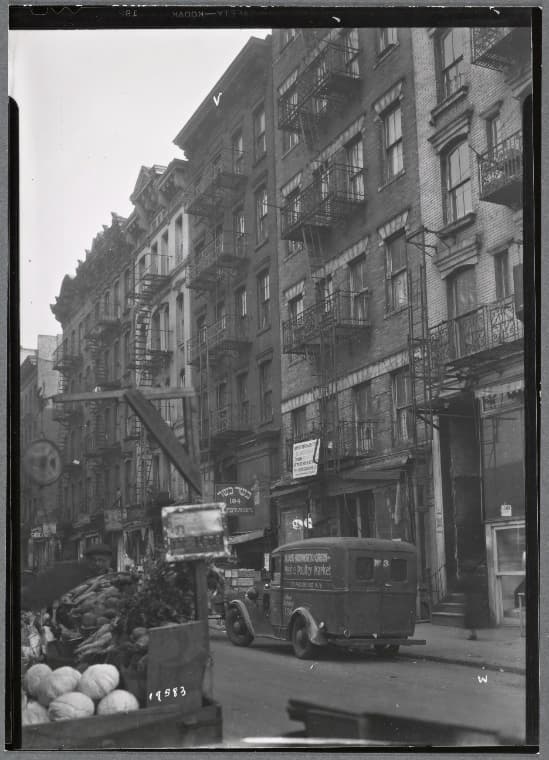
  • Tenements and storefronts; S. Katsowitz Groceries: 182-196 Orchard-E. Houston-Stanton, Manhattan, 1937

    Tenements and storefronts; S. Katsowitz Groceries: 182-196 Orchard-E. Houston-Stanton, Manhattan

    1937

Stand where these photos were taken

The free OldNYC app for iPhone centers the map on you and shows the historical photos taken closest to where you are.
Download on the App Store (opens the App Store)
QR code that opens OldNYC on the App Store

Or scan with your iPhone

Nearby places

  • Houston Street & Ludlow Street, Manhattan (9 photos)
  • 1st Street & 1st Avenue, Manhattan (57 photos)
  • 1st Ave & 2nd St, Manhattan (6 photos)
  • Allen Street & Stanton Street, Manhattan (4 photos)
  • Avenue A & 2nd Street, Manhattan (10 photos)
  • Houston Street & Forsyth Street, Manhattan (3 photos)
  • 1st Street & Avenue A, Manhattan (41 photos)
  • 3rd Street & 1st Avenue, Manhattan (9 photos)

Explore

  • Map
  • Browse by place
  • Browse by decade

Boroughs

  • Manhattan
  • Brooklyn
  • Queens
  • Bronx
  • Staten Island

About

  • About and contact
  • Privacy

Photos: The New York Public Library, Milstein Collection

OldNYC for iPhone

Find the historical photos taken closest to where you stand.

Download on the App Store (opens the App Store)QR code that opens OldNYC on the App Store
Manhattan: Houston Street (East) - Orchard Street, 1934

Photo 2 of 4 at Houston Street & Orchard Street, Manhattan

Manhattan: Houston Street (East) - Orchard Street

1934

(1) East Houston Street, south side (right), east from but not including Orchard Street, showing the clearance created between East Houston and East 1st (left) Streets, after the demolition of the tenements which faced on the north side of the former and the south side of the latter streets. The houses were razed to facilitate the construction of the Independent System Subway (Eighth Ave. Subway) and the clearance is now (1937) being utilized as a playground and park. Also shown (left) is East 1st Street, east from but not including First Ave. In the right background are visible several houses facing on the east side of Norfolk Street, as seen through clearance between Essex and Norfolk Streets. April 28, 1934. P. L. Sperr. (2) A portion of the same, from a different angle, excluding the view of East 1st Street (immediate foreground). April 28, 1934. P. L. Sperr.

Photo from the New York Public Library - Milstein Collection

See this spot on the mapView on NYPL Digital Collections (opens in a new tab)

See this photo in high resolution

Zoom into the full-resolution scan in the OldNYC app for iPhone with OldNYC Supporter ($4.99). The free app also centers the map on you, so you can find the photos taken closest to where you stand.
Download on the App Store (opens the App Store)
QR code that opens OldNYC on the App Store

Or scan with your iPhone