VVestiges of New York49,000+ historical photos
MapBrowseAboutGet the iPhone app (opens the App Store)
  1. Browse /
  2. Bronx /
  3. This place

Sacket Avenue & Colden Avenue, Bronx

1 historical photo taken here in 1913.

See this spot on the map

Photos

  • Bronx: Sacket Avenue - Colden Avenue, 1913

    Bronx: Sacket Avenue - Colden Avenue

    1913

Stand where these photos were taken

The free OldNYC app for iPhone centers the map on you and shows the historical photos taken closest to where you are.
Download on the App Store (opens the App Store)
QR code that opens OldNYC on the App Store

Or scan with your iPhone

Nearby places

  • St. Peter's Avenue & Tremont Avenue, Bronx (7 photos)
  • Odell Street & Archer Street, Bronx (7 photos)
  • Tremont Avenue (East & Silver Street, Bronx (3 photos)
  • Purdy Street & Parker Street, Bronx (2 photos)
  • Fowler Avenue & Van Nest Avenue, Bronx (2 photos)

Explore

  • Map
  • Browse by place
  • Browse by decade

Boroughs

  • Manhattan
  • Brooklyn
  • Queens
  • Bronx
  • Staten Island

About

  • About and contact
  • Privacy

Photos: The New York Public Library, Milstein Collection

OldNYC for iPhone

Find the historical photos taken closest to where you stand.

Download on the App Store (opens the App Store)QR code that opens OldNYC on the App Store
Bronx: Sacket Avenue - Colden Avenue, 1913

Photo 1 of 1 at Sacket Avenue & Colden Avenue, Bronx

Bronx: Sacket Avenue - Colden Avenue

1913

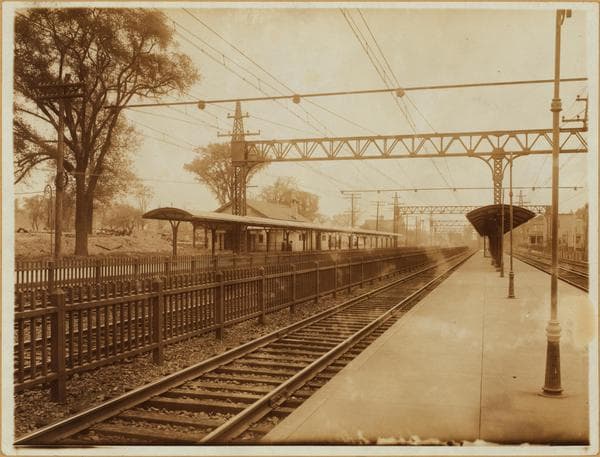
Socket Ave. (left, on which railway depot is located), north from Colden Ave., showing the Morris Park station of the New York, New Haven and Hartford Railroad. According to Bromley's map of 1900, an old Morris Park station was situated at what is now (1937) a plot adjoining the S.W. corner of Bronxdale and Van Nest Aves., near the railroad's present workshops. It was a frame depot at the very gate of the famous Morris Park Race Track. It was dismantled between 1900 and 1913 (Bromley maps) during which period many streets were laid out on the former track grounds and surrounding properties. The station here shown, was opened to passenger traffic in 1913 even though it had been completed for some time prior to that date. 1913.

Photo from the New York Public Library - Milstein Collection
See this spot on the mapView on NYPL Digital Collections (opens in a new tab)

See this photo in high resolution

Zoom into the full-resolution scan in the OldNYC app for iPhone with OldNYC Supporter ($4.99). The free app also centers the map on you, so you can find the photos taken closest to where you stand.
Download on the App Store (opens the App Store)
QR code that opens OldNYC on the App Store

Or scan with your iPhone