VVestiges of New York49,000+ historical photos
MapBrowseAboutGet the iPhone app (opens the App Store)
  1. Browse /
  2. Brooklyn /
  3. This place

East 55th Street & Beverly Road, Brooklyn

1 historical photo taken here between 1910 and 1923.

See this spot on the map

Photos

  • Brooklyn: 55th Street (East) - Beverly Road, 1910–1923

    Brooklyn: 55th Street (East) - Beverly Road

    1910; 1923

Stand where these photos were taken

The free OldNYC app for iPhone centers the map on you and shows the historical photos taken closest to where you are.
Download on the App Store (opens the App Store)
QR code that opens OldNYC on the App Store

Or scan with your iPhone

Nearby places

  • East 55th Street & Clarendon Road, Brooklyn (3 photos)
  • East 53rd Street & Beverly Road, Brooklyn (5 photos)
  • East 54th Street & Canarsie Avenue, Brooklyn (8 photos)
  • Kings Highway & Tilden Avenue, Brooklyn (5 photos)
  • Clarendon Road & East 59th Street, Brooklyn (6 photos)
  • Kings Highway & Snyder Avenue, Brooklyn (15 photos)

Explore

  • Map
  • Browse by place
  • Browse by decade

Boroughs

  • Manhattan
  • Brooklyn
  • Queens
  • Bronx
  • Staten Island

About

  • About and contact
  • Privacy

Photos: The New York Public Library, Milstein Collection

OldNYC for iPhone

Find the historical photos taken closest to where you stand.

Download on the App Store (opens the App Store)QR code that opens OldNYC on the App Store
Brooklyn: 55th Street (East) - Beverly Road, 1910–1923

Photo 1 of 1 at East 55th Street & Beverly Road, Brooklyn

Brooklyn: 55th Street (East) - Beverly Road

1910; 1923

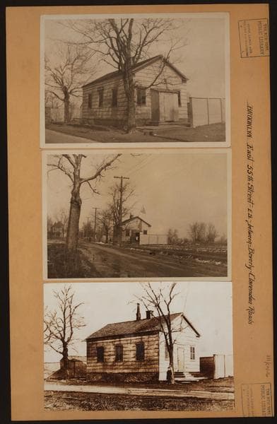
(1) East 55th Street, east side, between Beverly and Clarendon Roads, showing District School No. 2, also known as Flatlands Neck School. This structure was built in 1835 or 1837, to replace a smaller school house built in 1786. The older building had originally been standing a little further back, and was moved to the new site given by a member of the Lott Family, who needed the old site for building purposes. The building was razed in 1926, because the site was required for the widening of Kings Highway which cuts diagonally across East 55th Street at this point. March 1923. Eugene L. Armbruster Collection (2) The same, from another angle. March 1923. Eugene L. Armbruster Collection (3) The same, showing an earlier period. Prior to 1910? Eugene L. Armbruster Collection

Photo from the New York Public Library - Milstein Collection
See this spot on the mapView on NYPL Digital Collections (opens in a new tab)

See this photo in high resolution

Zoom into the full-resolution scan in the OldNYC app for iPhone with OldNYC Supporter ($4.99). The free app also centers the map on you, so you can find the photos taken closest to where you stand.
Download on the App Store (opens the App Store)
QR code that opens OldNYC on the App Store

Or scan with your iPhone