VVestiges of New York49,000+ historical photos
MapBrowseAboutGet the iPhone app (opens the App Store)
  1. Browse /
  2. Manhattan /
  3. This place

Chittenden Place & West 186th Street, Manhattan

3 historical photos taken here between 1934 and 1938, oldest first.

See this spot on the map

Photos

  • Manhattan: Chittenden Place - 186th Street (West), 1934–1938

    Manhattan: Chittenden Place - 186th Street (West)

    1934; 1938

  • Manhattan: Chittenden Place - 186th Street (West), 1934–1938

    Manhattan: Chittenden Place - 186th Street (West)

    1934; 1938

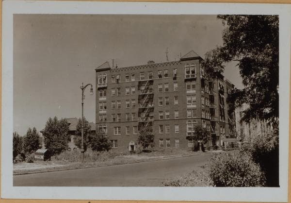
  • Manhattan: Cabrini Boulevard - 186th Street (West), 1938

    Manhattan: Cabrini Boulevard - 186th Street (West)

    1938

Stand where these photos were taken

The free OldNYC app for iPhone centers the map on you and shows the historical photos taken closest to where you are.
Download on the App Store (opens the App Store)
QR code that opens OldNYC on the App Store

Or scan with your iPhone

Nearby places

  • East 187th Street & Northern Avenue, Manhattan (6 photos)
  • Chittenden Avenue & West 187th Street, Manhattan (2 photos)
  • Fort Washington Avenue & West 187th Street, Manhattan (8 photos)
  • Northern Avenue & West 190th Street, Manhattan (3 photos)
  • Pinehurst Avenue & West 183rd Street, Manhattan (6 photos)
  • Fort Washington Avenue & 190th Street, Manhattan (13 photos)
  • Fort Washington Avenue & West 183rd Street, Manhattan (13 photos)
  • Riverside Drive & 181st Street, Manhattan (10 photos)

Explore

  • Map
  • Browse by place
  • Browse by decade

Boroughs

  • Manhattan
  • Brooklyn
  • Queens
  • Bronx
  • Staten Island

About

  • About and contact
  • Privacy

Photos: The New York Public Library, Milstein Collection

OldNYC for iPhone

Find the historical photos taken closest to where you stand.

Download on the App Store (opens the App Store)QR code that opens OldNYC on the App Store
Manhattan: Chittenden Place - 186th Street (West), 1934–1938

Photo 2 of 3 at Chittenden Place & West 186th Street, Manhattan

Manhattan: Chittenden Place - 186th Street (West)

1934; 1938

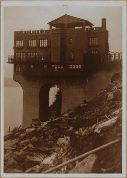
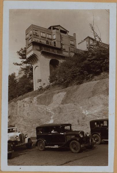
16 Chittenden Place, west side, at the extremity of W. 186th Street, showing an overhanging structure built by an architect for self occupancy. An engraving of same by Vernon Howe Bailey appeared in the New York Sun of May 1934. The photographers vantage point is Riverside Drive, which appears in the foreground and he is viewing northeastward. June 23, 1934. P.L. Sperr A similar view from Dr. Chas. V. Paterno's estate, the adjoining property, and upon which is being constructed, the distinctive Castle Village. Note debris from same in the foreground. The photographer is viewing northwestward from atop the bluff, Cabrini Blvd. (formerly Northern Avenue). October 21, 1938 George D. Chinn

Photo from the New York Public Library - Milstein Collection

See this spot on the mapView on NYPL Digital Collections (opens in a new tab)

See this photo in high resolution

Zoom into the full-resolution scan in the OldNYC app for iPhone with OldNYC Supporter ($4.99). The free app also centers the map on you, so you can find the photos taken closest to where you stand.
Download on the App Store (opens the App Store)
QR code that opens OldNYC on the App Store

Or scan with your iPhone