East 85th Street & East End Avenue, Manhattan
7 historical photos taken here between 1931 and 1935, oldest first.
Photos
![East River - Shore and skyline of Manhattan from East 85th Street - Queensborough Bridge - [Interboro Rapid Transit Building; New York Hospital; Yorkville Ice Sales Corporation.], 1931–1933](/_next/image?url=https%3A%2F%2Fimages.vestigesofnewyork.com%2F600px%2F2dbd5dba-e32b-424d-bc4f-427f1c22830a.jpg&w=1080&q=75)
East River - Shore and skyline of Manhattan from East 85th Street - Queensborough Bridge - [Interboro Rapid Transit Building; New York Hospital; Yorkville Ice Sales Corporation.]
1931; 1933
![East River - Shore and skyline of Manhattan between East 85th and 92nd Streets - Queensborough Bridge - [Doctor's Hospital - Municipal Asphalt Plant - Miss Chapin's School.], 1931–1933](/_next/image?url=https%3A%2F%2Fimages.vestigesofnewyork.com%2F600px%2F4e1133e9-a2bd-4f0d-9df0-a0433e723fe8.jpg&w=1080&q=75)
East River - Shore and skyline of Manhattan between East 85th and 92nd Streets - Queensborough Bridge - [Doctor's Hospital - Municipal Asphalt Plant - Miss Chapin's School.]
1931; 1933
![East River - Shore and skyline of Manhattan from East 85th Street - Queensborough Bridge - [Interboro Rapid Transit Building; New York Hospital; Yorkville Ice Sales Corporation.], 1931–1933](/_next/image?url=https%3A%2F%2Fimages.vestigesofnewyork.com%2F600px%2F88d918cd-079b-48b5-aa83-defaec9c93a5.jpg&w=1080&q=75)
East River - Shore and skyline of Manhattan from East 85th Street - Queensborough Bridge - [Interboro Rapid Transit Building; New York Hospital; Yorkville Ice Sales Corporation.]
1931; 1933
![East River - Shore and skyline of Manhattan between East 85th and 92nd Streets - Queensborough Bridge - [Doctor's Hospital - Municipal Asphalt Plant - Miss Chapin's School.], 1931–1933](/_next/image?url=https%3A%2F%2Fimages.vestigesofnewyork.com%2F600px%2Fcbc8b472-1273-4729-bb52-204958042aeb.jpg&w=1080&q=75)
East River - Shore and skyline of Manhattan between East 85th and 92nd Streets - Queensborough Bridge - [Doctor's Hospital - Municipal Asphalt Plant - Miss Chapin's School.]
1931; 1933
![East River - Shore and skyline of Manhattan between East 85th and 92nd Streets - Queensborough Bridge - [Doctor's Hospital - Municipal Asphalt Plant - Miss Chapin's School.], 1931–1933](/_next/image?url=https%3A%2F%2Fimages.vestigesofnewyork.com%2F600px%2Fd6bdd2b1-2418-414c-a5cf-bf3d50204361.jpg&w=1080&q=75)
East River - Shore and skyline of Manhattan between East 85th and 92nd Streets - Queensborough Bridge - [Doctor's Hospital - Municipal Asphalt Plant - Miss Chapin's School.]
1931; 1933
![East River - Shore and skyline of Manhattan from East 85th Street - Queensborough Bridge - [Interboro Rapid Transit Building; New York Hospital; Yorkville Ice Sales Corporation.], 1931–1933](/_next/image?url=https%3A%2F%2Fimages.vestigesofnewyork.com%2F600px%2Fe1914fcc-d040-4a1a-8ce6-601c2dd739a1.jpg&w=1080&q=75)
East River - Shore and skyline of Manhattan from East 85th Street - Queensborough Bridge - [Interboro Rapid Transit Building; New York Hospital; Yorkville Ice Sales Corporation.]
1931; 1933
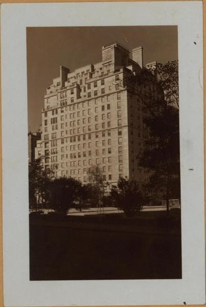
Manhattan: 85th Street (East) - East End Avenue
Nearby places
- East End Avenue & 84th Street, Manhattan (13 photos)
- East End Avenue & 86th Street, Manhattan (14 photos)
- Carl Schurz Park, Manhattan (11 photos)
- 527-529 East 85th Street & Madison Avenue, Manhattan (2 photos)
- East River Drive & Gracie Square, Manhattan (40 photos)
- East 83rd Street & East End Avenue, Manhattan (5 photos)
- Carl Schurz Park: Gracie Mansion, Manhattan (39 photos)
- York Avenue & 85th Street, Manhattan (2 photos)