VVestiges of New York49,000+ historical photos
MapBrowseAboutGet the iPhone app (opens the App Store)
  1. Browse /
  2. Manhattan /
  3. This place

East River Drive & East 49th Street, Manhattan

9 historical photos taken here between 1927 and 1939, oldest first.

See this spot on the map

Photos

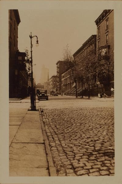
  • Manhattan: 50th Street - Beckman Place, 1927

    Manhattan: 50th Street - Beckman Place
    1927

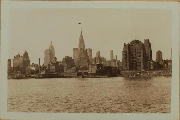
  • East River - Shore and skyline of Manhattan between East 45th and 51st Streets - Williamsburg and Queensborough Bridges., 1933

    East River - Shore and skyline of Manhattan between East 45th and 51st Streets - Williamsburg and Queensborough Bridges.

    1933

  • East River - Shore and skyline of Manhattan between East 49th and 53rd Streets - Williamsburg and Queensborough Bridges - [United States Volunteer Life Saving Corps.], 1933–1934

    East River - Shore and skyline of Manhattan between East 49th and 53rd Streets - Williamsburg and Queensborough Bridges - [United States Volunteer Life Saving Corps.]

    1933; 1934

  • East River - Shore and skyline of Manhattan between East 49th and 53rd Streets - Williamsburg and Queensborough Bridges - [United States Volunteer Life Saving Corps.], 1933–1934

    East River - Shore and skyline of Manhattan between East 49th and 53rd Streets - Williamsburg and Queensborough Bridges - [United States Volunteer Life Saving Corps.]

    1933; 1934

  • East River - Shore and skyline of Manhattan between East 49th and 53rd Streets - Williamsburg and Queensborough Bridges - [United States Volunteer Life Saving Corps.], 1933–1934

    East River - Shore and skyline of Manhattan between East 49th and 53rd Streets - Williamsburg and Queensborough Bridges - [United States Volunteer Life Saving Corps.]

    1933; 1934

  • East River - Shore and skyline of Manhattan between East 45th and 51st Streets - Williamsburg and Queensborough Bridges., 1933

    East River - Shore and skyline of Manhattan between East 45th and 51st Streets - Williamsburg and Queensborough Bridges.
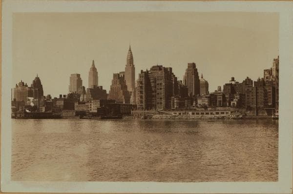
    1933

  • East River - Shore and skyline of Manhattan between East 45th and 51st Streets - Williamsburg and Queensborough Bridges., 1933

    East River - Shore and skyline of Manhattan between East 45th and 51st Streets - Williamsburg and Queensborough Bridges.

    1933

  • Manhattan: East River Drive - 49th Street (East), 1939

    Manhattan: East River Drive - 49th Street (East)

    1939

  • Manhattan: East River Drive - 49th Street (East), 1939

    Manhattan: East River Drive - 49th Street (East)

    1939

Stand where these photos were taken

The free OldNYC app for iPhone centers the map on you and shows the historical photos taken closest to where you are.
Download on the App Store (opens the App Store)
QR code that opens OldNYC on the App Store

Or scan with your iPhone

Nearby places

  • East 48th Street & East River Drive, Manhattan (2 photos)
  • 1st Ave & 51st St. E, Manhattan (13 photos)
  • Beekman Place & East 49th Street, Manhattan (5 photos)
  • 1st Ave & 49th St. E, Manhattan (7 photos)
  • East 52nd Street & 96th Avenue, Manhattan (2 photos)
  • 1st Ave & 48th St, Manhattan (12 photos)
  • 52nd Street & 1st Avenue, Manhattan (4 photos)
  • East 47th Street & 1st Avenue, Manhattan (12 photos)

Explore

  • Map
  • Browse by place
  • Browse by decade

Boroughs

  • Manhattan
  • Brooklyn
  • Queens
  • Bronx
  • Staten Island

About

  • About and contact
  • Privacy

Photos: The New York Public Library, Milstein Collection

OldNYC for iPhone

Find the historical photos taken closest to where you stand.

Download on the App Store (opens the App Store)QR code that opens OldNYC on the App Store
East River - Shore and skyline of Manhattan between East 49th and 53rd Streets - Williamsburg and Queensborough Bridges - [United States Volunteer Life Saving Corps.], 1933–1934

Photo 4 of 9 at East River Drive & East 49th Street, Manhattan

East River - Shore and skyline of Manhattan between East 49th and 53rd Streets - Williamsburg and Queensborough Bridges - [United States Volunteer Life Saving Corps.]

1933; 1934

(1) East River, from East 49th (left), to East 53rd Streets, showing (facing on the water-front) the 15-story house No. 1 Beekman Place, at the N.E. corner of East 49th Street, the 15-story Campanile on the south side of East 52nd Street, and the 26-story River House, from East 52nd to East 53rd Streets. Also shown (center background, right to left) are; the General Electric Co. Building, the R.C.A. Building and the Hotel Waldorf-Astoria. The point of vantage is Welfare Island. May 4, 1933. P. L. Sperr. (2) The same, a more limited view. The vantage point is Welfare Island. May 4, 1933. P. L. Sperr. (3) The same, north from East 51st Street; and showing a portion of the Queensborough Bridge. In the foreground is visible the 1-story (white) building of the Volunteer Life Saving Co. July 3, 1934. P. L. Sperr.

Photo from the New York Public Library - Milstein Collection

See this spot on the mapView on NYPL Digital Collections (opens in a new tab)

See this photo in high resolution

Zoom into the full-resolution scan in the OldNYC app for iPhone with OldNYC Supporter ($4.99). The free app also centers the map on you, so you can find the photos taken closest to where you stand.
Download on the App Store (opens the App Store)
QR code that opens OldNYC on the App Store

Or scan with your iPhone