VVestiges of New York49,000+ historical photos
MapBrowseAboutGet the iPhone app (opens the App Store)
  1. Browse /
  2. Manhattan /
  3. This place

Stuyvesant Street, Manhattan

4 historical photos taken here in 1960, oldest first.

See this spot on the map

Photos

  • Manhattan: Stuyvesant Street, 1960

    Manhattan: Stuyvesant Street

    1960

  • Manhattan: Stuyvesant Street, 1960

    Manhattan: Stuyvesant Street

    1960

  • Manhattan: Stuyvesant Street, 1960

    Manhattan: Stuyvesant Street

    1960

  • Manhattan: Stuyvesant Street, 1960

    Manhattan: Stuyvesant Street

    1960

Stand where these photos were taken

The free OldNYC app for iPhone centers the map on you and shows the historical photos taken closest to where you are.
Download on the App Store (opens the App Store)
QR code that opens OldNYC on the App Store

Or scan with your iPhone

Nearby places

  • 2nd Ave & Stuyvesant St, Manhattan (43 photos)
  • St. Marks Place & 2nd Avenue, Manhattan (11 photos)
  • East 11th Street & 3rd Avenue, Manhattan (17 photos)
  • 3rd Avenue & 9th Street, Manhattan (14 photos)
  • 2nd Ave & 12th St. E, Manhattan (4 photos)
  • 4th Avenue & 10th Street, Manhattan (12 photos)
  • 7th Street & 3rd Avenue, Manhattan (4 photos)
  • 2nd Ave & 7th St, Manhattan (3 photos)

Explore

  • Map
  • Browse by place
  • Browse by decade

Boroughs

  • Manhattan
  • Brooklyn
  • Queens
  • Bronx
  • Staten Island

About

  • About and contact
  • Privacy

Photos: The New York Public Library, Milstein Collection

OldNYC for iPhone

Find the historical photos taken closest to where you stand.

Download on the App Store (opens the App Store)QR code that opens OldNYC on the App Store
Manhattan: Stuyvesant Street, 1960

Photo 2 of 4 at Stuyvesant Street, Manhattan

Manhattan: Stuyvesant Street

1960

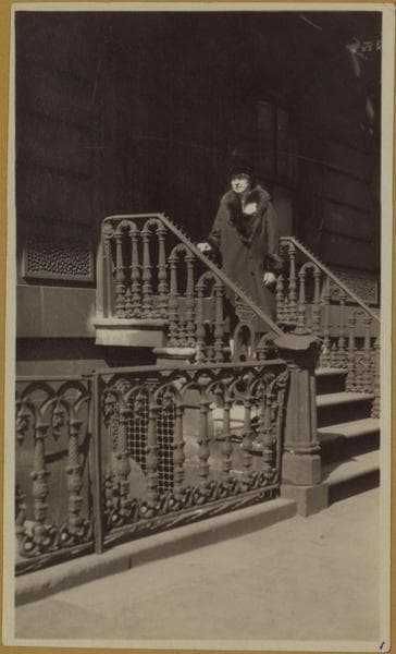
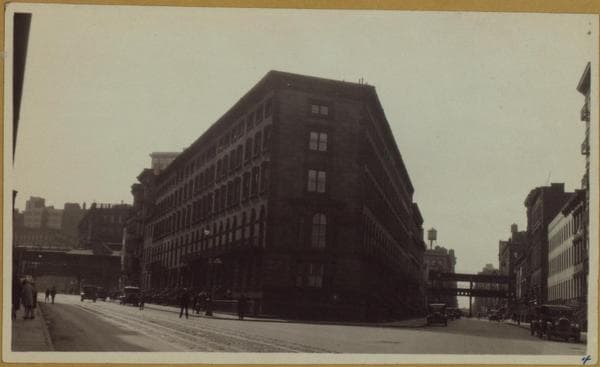
View 1: Entrance to 33 Stuyvesant Street, New York 3, New York. Showing sections of hand-wrought iron work on fence, and entrance balustrades (the iron work forming a second-floor gallery surrounding the four buildings forming the point where East 10th Street and Stuyvesant Street meet does not show here. The blunt point of this group of houses (33 & 35 Stuyvesant Street and 126 & 128 E. 10th St.) is probably a few hundred feet from the entrance to St. Mark's Church-in-the-Bowery; this church for a number of years owned these properties along with a number of others on E. 10th St. and East 11th St. Gift of Lilian Gibbs, 21 May 1960. (Photograph, n.d.) View 2: Same, but also showing the second-floor gallery surrounding the four buildings forming the point where E. 10th St. and Stuyvesant Street meet. The iron work was demolished when it began to disintegrate. Gift of Lilian Gibbs, 21 May 1960. (Photograph, n.d.) View 3: Entrance to basement apartment, 33 Stuyvesant Street, after the iron fence was removed. Gift of Lilian Gibbs, 21 May 1960. View 4: This picture shows the converging of E. 10th Street and Stuyvesant Street with sections of the "el" showing at East 9th St.("el" station) and East 10th St. (tracks). Cable car tracks leading from Astor Place traversed Stuyvesant Street and eastward (or westward as desired by the switchman) and returned westward on E. 9th St. The ornate hand-wrought iron fencing and balustrade are barely discernable here, but they added charm and grace as long as they held forth. Gift of Lilian Gibbs, 21 May 1960. (Photograph, n.d.)

Photo from the New York Public Library - Milstein Collection

See this spot on the mapView on NYPL Digital Collections (opens in a new tab)

See this photo in high resolution

Zoom into the full-resolution scan in the OldNYC app for iPhone with OldNYC Supporter ($4.99). The free app also centers the map on you, so you can find the photos taken closest to where you stand.
Download on the App Store (opens the App Store)
QR code that opens OldNYC on the App Store

Or scan with your iPhone