VVestiges of New York49,000+ historical photos
MapBrowseAboutGet the iPhone app (opens the App Store)
  1. Browse /
  2. Queens /
  3. This place

29th Street & 11th Avenue, Queens

3 historical photos taken here in 1932, oldest first.

See this spot on the map

Photos

  • Queens: 29th Street - 11th Avenue, 1932

    Queens: 29th Street - 11th Avenue

    1932

  • Queens: 29th Street - 11th Avenue, 1932

    Queens: 29th Street - 11th Avenue

    1932

  • Queens: 29th Street - 11th Avenue, 1932

    Queens: 29th Street - 11th Avenue

    1932

Stand where these photos were taken

The free OldNYC app for iPhone centers the map on you and shows the historical photos taken closest to where you are.
Download on the App Store (opens the App Store)
QR code that opens OldNYC on the App Store

Or scan with your iPhone

Nearby places

  • 39th Avenue & 30th Street, Queens (2 photos)
  • Northern Boulevard & 31st Street, Queens (2 photos)
  • 30th Street & 40th Avenue, Queens (2 photos)
  • 29th Street & 40th Avenue, Queens (4 photos)
  • Grand Central Parkway & 50th Avenue, Queens (2 photos)
  • 29th Street & 41st Avenue, Queens (4 photos)
  • Northern Boulevard & 41st Avenue, Queens (2 photos)
  • 24th Avenue & 38th Street, Queens (2 photos)

Explore

  • Map
  • Browse by place
  • Browse by decade

Boroughs

  • Manhattan
  • Brooklyn
  • Queens
  • Bronx
  • Staten Island

About

  • About and contact
  • Privacy

Photos: The New York Public Library, Milstein Collection

OldNYC for iPhone

Find the historical photos taken closest to where you stand.

Download on the App Store (opens the App Store)QR code that opens OldNYC on the App Store
Queens: 29th Street - 11th Avenue, 1932

Photo 3 of 3 at 29th Street & 11th Avenue, Queens

Queens: 29th Street - 11th Avenue

1932

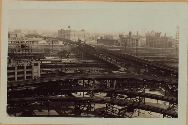
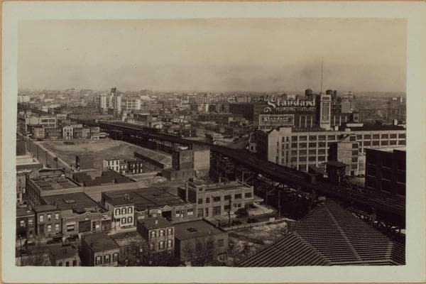
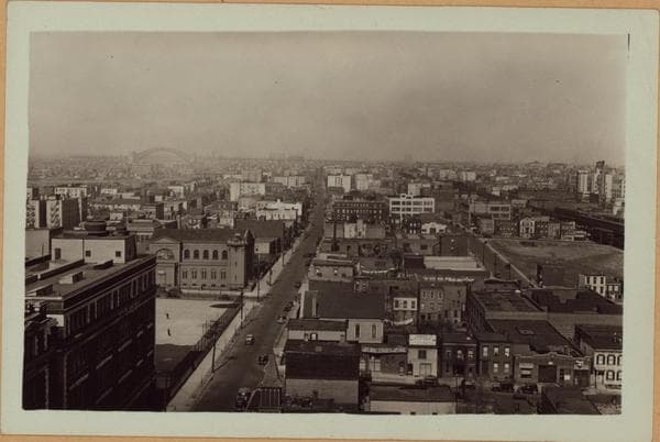
Long Island City, Queens: Shown is a general view, in a northeasterly direction, of Long Island City, seen from Bridge Plaza North and 29th Street. Many of the industrial buildings and old-type tenements are clearly visible. Shown, too, is the elevated structure, which carries the I.R.T. trains to Astoria, on 31st Street and the 39th Avenue station. Northern Boulevard, on which part of the "El" is on, can be seen bending eastward around the Standard Plumbing building. In the lower right-hand corner is part of the Queensboro Stadium. View 2 is directly north, from the same point, along 29th Street toward Astoria and the Hellgate Bridge. At the lower left-hand corner is Bryant High School, and north of the playground is St. Patricks Roman Catholic Church. View 3 is eastward across the Pennsylvania Railroad yards, viewing along Queens Boulevard on which the "El" runs toward Flushing. The elevated loop in the foreground is the Astoria line. Across the freight yards are numerous industrial plants. P. L. Sperr *Long Island City* March 23, 1932 Views 1,2,3

Photo from the New York Public Library - Milstein Collection
See this spot on the mapView on NYPL Digital Collections (opens in a new tab)

See this photo in high resolution

Zoom into the full-resolution scan in the OldNYC app for iPhone with OldNYC Supporter ($4.99). The free app also centers the map on you, so you can find the photos taken closest to where you stand.
Download on the App Store (opens the App Store)
QR code that opens OldNYC on the App Store

Or scan with your iPhone