VVestiges of New York49,000+ historical photos
MapBrowseAboutGet the iPhone app (opens the App Store)
  1. Browse /
  2. Queens /
  3. This place

Maspeth Avenue & 57th Street, Queens

5 historical photos taken here between 1922 and 1925, oldest first.

See this spot on the map

Photos

  • Queens: Maspeth Avenue - 57th Street, 1923

    Queens: Maspeth Avenue - 57th Street

    1923

  • Queens: Maspeth Avenue - 57th Street, 1922–1925

    Queens: Maspeth Avenue - 57th Street

    1922; 1924; 1925

  • Queens: Maspeth Avenue - 57th Street, 1922–1925

    Queens: Maspeth Avenue - 57th Street

    1922; 1924; 1925

  • Queens: Maspeth Avenue - 57th Street, 1922–1925

    Queens: Maspeth Avenue - 57th Street

    1922; 1924; 1925

  • Queens: Maspeth Avenue - 57th Street, 1922–1925

    Queens: Maspeth Avenue - 57th Street

    1922; 1924; 1925

Stand where these photos were taken

The free OldNYC app for iPhone centers the map on you and shows the historical photos taken closest to where you are.
Download on the App Store (opens the App Store)
QR code that opens OldNYC on the App Store

Or scan with your iPhone

Nearby places

  • Maspeth Avenue & 55th Street, Queens (8 photos)
  • Maspeth Avenue & 54th Street, Queens (4 photos)
  • Grand Avenue & 58th Street, Queens (3 photos)
  • Grand Avenue & 59th Street, Queens (4 photos)
  • Flushing Avenue & 52nd Street, Queens (7 photos)

Explore

  • Map
  • Browse by place
  • Browse by decade

Boroughs

  • Manhattan
  • Brooklyn
  • Queens
  • Bronx
  • Staten Island

About

  • About and contact
  • Privacy

Photos: The New York Public Library, Milstein Collection

OldNYC for iPhone

Find the historical photos taken closest to where you stand.

Download on the App Store (opens the App Store)QR code that opens OldNYC on the App Store
Queens: Maspeth Avenue - 57th Street, 1922–1925

Photo 5 of 5 at Maspeth Avenue & 57th Street, Queens

Queens: Maspeth Avenue - 57th Street

1922; 1924; 1925

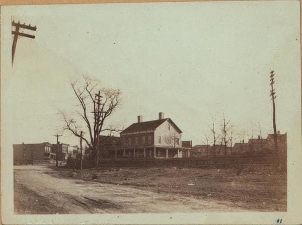
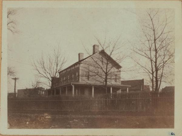
(1-4) Maspeth Ave. (foreground), east of 57th Street, showing in the foreground the Queens Head Tavern which is on the S.E. corner of Maspeth Ave. and 58th Street (along line of telegraph poles at the right.) This homestead was founded by James Way who left his estate to his nephew, Samuel Way in the middle of the 18th Century. In 1815, Garret Furman acquired the land. Captain Peter Berton ran a tavern here in July 1783. In 1873 McCrady and Elder operated it as a hotel. Another history concerning this house is that it was erected by the town of Newtown and leased to tavern keepers. It was a resort for the soldiers during the Revolutionary war; later a stage stop, and afterwards a private dwelling. A gas station and tavern occupied the place in 1933. In front of this tavern was a toll house, in 1852. This is a set of three views from slightly different angles. January 1924. View 2: 1922. View 3: January 1924. View 4: March 1925 Eugene L. Armbruster Collection.

Photo from the New York Public Library - Milstein Collection

See this spot on the mapView on NYPL Digital Collections (opens in a new tab)

See this photo in high resolution

Zoom into the full-resolution scan in the OldNYC app for iPhone with OldNYC Supporter ($4.99). The free app also centers the map on you, so you can find the photos taken closest to where you stand.
Download on the App Store (opens the App Store)
QR code that opens OldNYC on the App Store

Or scan with your iPhone