VVestiges of New York49,000+ historical photos
MapBrowseAboutGet the iPhone app (opens the App Store)
  1. Browse /
  2. Staten Island /
  3. This place

Richmond Avenue & Dongan Hills Avenue, Staten Island

2 historical photos taken here between 1920 and 1936, oldest first.

See this spot on the map

Photos

  • Richmond: Richmond Avenue - Dongan Hills Avenue, 1920–1936

    Richmond: Richmond Avenue - Dongan Hills Avenue

    1920; 1936

  • Richmond: Richmond Avenue - Dongan Hills Avenue, 1920–1936

    Richmond: Richmond Avenue - Dongan Hills Avenue

    1920; 1936

Stand where these photos were taken

The free OldNYC app for iPhone centers the map on you and shows the historical photos taken closest to where you are.
Download on the App Store (opens the App Store)
QR code that opens OldNYC on the App Store

Or scan with your iPhone

Nearby places

  • Richmond Road & Buel Avenue, Staten Island (4 photos)
  • Richmond Road & Liberty Avenue, Staten Island (3 photos)
  • Romer Road & Four Corners Road, Staten Island (2 photos)
  • Romer Road & St. George Road, Staten Island (2 photos)
  • Richmond Road & Jefferson Avenue, Staten Island (2 photos)
  • Richmond Road & Norden Street, Staten Island (6 photos)
  • Flagg's pond, Staten Island (15 photos)

Explore

  • Map
  • Browse by place
  • Browse by decade

Boroughs

  • Manhattan
  • Brooklyn
  • Queens
  • Bronx
  • Staten Island

About

  • About and contact
  • Privacy

Photos: The New York Public Library, Milstein Collection

OldNYC for iPhone

Find the historical photos taken closest to where you stand.

Download on the App Store (opens the App Store)QR code that opens OldNYC on the App Store
Richmond: Richmond Avenue - Dongan Hills Avenue, 1920–1936

Photo 1 of 2 at Richmond Avenue & Dongan Hills Avenue, Staten Island

Richmond: Richmond Avenue - Dongan Hills Avenue

1920; 1936

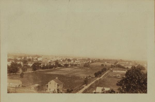
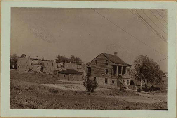
(1) 1682 Richmond Avenue, (house in foreground), at the N.E. corner of Dongan Hills Avenue, showing the old J. Barnes House. Butler's and Beers's maps of 1853 and 1874, respectively, show the house to have been owned by J. Barnes. In 1898 it belonged to Captain E. F. Keegan and was then known as "Sunny Side"; in 1907 the Dongan Hill Feed and Grain Company owned it; and in 1917 the Richmond County Agricultural Society. Mr. P. L. Sperr states that this house is an Egbert house; the writer of these lines did not, however, find any evidence in support of the statement. Though a large tract of land belonging to J. Egbert lay directly north of the house and adjoined the Barnes property, the maps of the aforementioned dates do not show the dwelling to have belonged to Egbert. It may, though, have belonged to Egbert at an earlier date. The view is eastward across Dongan Hills toward the Lower New York Bay and Hoffman Island, as seen from Flagg Place. 1920's P. L. Sperr (2) An exclusive view of the house. May 10, 1936 P. L. Sperr

Photo from the New York Public Library - Milstein Collection
See this spot on the mapView on NYPL Digital Collections (opens in a new tab)

See this photo in high resolution

Zoom into the full-resolution scan in the OldNYC app for iPhone with OldNYC Supporter ($4.99). The free app also centers the map on you, so you can find the photos taken closest to where you stand.
Download on the App Store (opens the App Store)
QR code that opens OldNYC on the App Store

Or scan with your iPhone