VVestiges of New York49,000+ historical photos
MapBrowseAboutGet the iPhone app (opens the App Store)
  1. Browse /
  2. Staten Island /
  3. This place

Westcott Boulevard & Kemball Avenue, Staten Island

1 historical photo taken here in 1905.
See this spot on the map

Photos

  • Richmond: Westcott Boulevard - Kemball Avenue, 1905

    Richmond: Westcott Boulevard - Kemball Avenue

    1905

Stand where these photos were taken

The free OldNYC app for iPhone centers the map on you and shows the historical photos taken closest to where you are.
Download on the App Store (opens the App Store)
QR code that opens OldNYC on the App Store

Or scan with your iPhone

Nearby places

  • Jewett Avenue & Waters Avenue, Staten Island (2 photos)
  • Jewett Avenue & Leonard Avenue, Staten Island (3 photos)
  • Jewett Avenue & Victory Boulevard, Staten Island (6 photos)

Explore

  • Map
  • Browse by place
  • Browse by decade

Boroughs

  • Manhattan
  • Brooklyn
  • Queens
  • Bronx
  • Staten Island

About

  • About and contact
  • Privacy

Photos: The New York Public Library, Milstein Collection

OldNYC for iPhone

Find the historical photos taken closest to where you stand.

Download on the App Store (opens the App Store)QR code that opens OldNYC on the App Store
Richmond: Westcott Boulevard - Kemball Avenue, 1905

Photo 1 of 1 at Westcott Boulevard & Kemball Avenue, Staten Island

Richmond: Westcott Boulevard - Kemball Avenue

1905

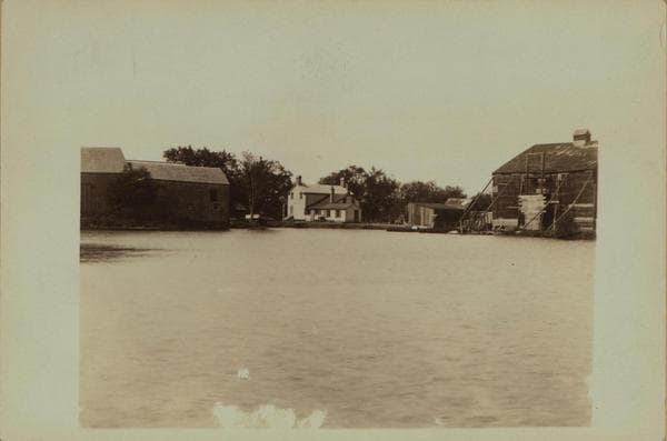
Westcott Boulevard, at Kemball Avenue. Shown is an old farmstead before Westcott Boulevard was laid out on the site of the pond (Mr. Sperr refers to it as Lust's Pond), the view being in a southerly direction and marking the direction in which Westcott Boulevard runs. Butler's 1853 map shows this to be on the P. Laforge property; Beers's 1874 map indicates the house to have been the mining captain's residence of the Richmond Iron Mining Company, whose iron mines were nearby. In 1898 and 1907 it was part of the J.W. Cochrane property and the pond was known as "Diamond Lake." Kemball, Chandler and Coale Avenues now (1940) cut across the site from east to west. Before the new thoroughfares were laid out the pond(and homestead) was located about 500 feet north of Victory Boulevard, slightly east of Jewett Avenue. About 1905 By Mulford Simonson From Staten Island Museum Collection through P. L. Sperr

Photo from the New York Public Library - Milstein Collection

See this spot on the mapView on NYPL Digital Collections (opens in a new tab)

See this photo in high resolution

Zoom into the full-resolution scan in the OldNYC app for iPhone with OldNYC Supporter ($4.99). The free app also centers the map on you, so you can find the photos taken closest to where you stand.
Download on the App Store (opens the App Store)
QR code that opens OldNYC on the App Store

Or scan with your iPhone